Firstly, Roman maps were primarily made on paper, which was not really prominent until the shift to a written culture began. Although more image-based than text-based, maps are still very much linked to a written tradition. Maps would have been very important to Rome for several reasons. One is certainly the management of its road system, but another (more important) reason is that if you want to become an empire and expand your domain, you have to know where there are people (and subsequently where there is land). Maps greatly aided this as one knew where to go (and where was most likely to contain riches) and were therefore very important from a militaristic standpoint. After all, Rome didn't want her soldiers pulling an Odysseus on their way home...

A map showing the various places where the Greek hero Odysseus went as he tried to get back home to Ithaca (middle right) after the siege of Troy (far right).
The more interesting question about Roman cartography is therefore not why they made maps but how they made maps, what their maps looked like. The Romans, of course, did not know about the Americas, but this was certainly not the only gaping hole in their cartography. The Romans would have known about the Orient as Western civilizations before Rome (including Greece) had traded with China, but what was to the north of China and the east of the Slavic people? (Siberia/Eastern Russia) Was there anything south of China past the kingdoms known there? (Essentially past Siam; think Indonesia and Australia) Was there anything in Africa south of ancient, scorching Nubia or anything north of the frigid Norse? (in this case, the answer is "no, not really.") Oh, and some geographers still thought the world was flat... That was kind of a misconception...
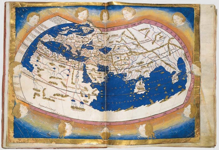
The leading geographer (and scientist) of the Roman Empire was Ptolemy. Ptolemy believed that the earth was in fact spherical, but he did have his own misconceptions. A reproduction (c. 15th century) of one of Ptolemy's maps (2nd century) is shown below.
 Oh, look! We live in the ocean!
It may be a little difficult to see, but Spain and the west coast of northern Africa are the furthest things to the west, and China is the furthest thing to the east (though unless I am mistaken, Ptolemy should have known about Japan as well). The furthest things to the north are the Norwegian peninsula (the thing to the east of Britain that kind of looks like Greenland but isn't) and the presumed vast wilderness of eastern Russia. The white to the south more likely represents the vast unknown, just like that in Russia, than Antarctica, especially when one considers that the southern-most land actually shown is the eastern horn of Africa, barely in the southern hemisphere. If we exclude these exclusions, size errors are the main problem with Ptolemy's map (although it is a little puzzling to me that what appears to be India is an island... I haven't figured out that one).

Another copy of the same map, which is generally harder to see but gives a better idea of water and the extent of the Roman's knowledge.
So basically, the Romans created maps once they had developed their written culture more (or as part of developing their written culture more) so that they could better manage their road systems (which I didn't talk about as much because I thought it pretty self-explanatory) and their empire's expansion. Roman cartography (and most of that of antiquity) was much more advanced than we tend to give it credit for. The general lack of the western hemisphere is a little problematic, but the northwestern quadrant (which contains the most landmass) is fairly accurate. Most of the Roman geographers believed the earth was round, which is very important when one considers that some (*cough* ignorant imbeciles *cough*) - people think that Columbus thought the earth was flat. Who knew the Romans knew so much about the world as they did?
Interesting. I hadn't thought about the connection between writing and exploring before. Of course it would be necessary to document land for larger civilizations, especially when expanding. However, if you had a smaller civilization where everyone knew the land, would it be necessary to have maps?
ReplyDeleteWow, I am really impressed at their maps! As I was reading your post and thinking to myself the reality of exploring new territories ange having to document them little by little without seeing the "big picture" seems unbelievably difficult. I am at awe at how well they did, seeing as they did not have suitable technology for it. And I live the insight that writing came hand in hand with map making and exploring.
ReplyDelete